Satellite remote detection—using satellite-based sensors to collect information about the Earth's surface and atmosphere—has become our silent sentinel in the sky. From the creep of climate change to the complexities of global supply chains and the seismic shifts in geopolitics, satellite remote detection delivers vital intelligence to navigate today’s uncertainties.
But this celestial promise can only be realized when human expertise guides the analytical process.
In this post, we’ll explore the challenges faced when incorporating satellite remote sensing into business intelligence operations—and how BCG X's 10/20/70 strategy can help organizations overcome these hurdles.
From Government Exploration to Business Intelligence: A New Era of Remote Detection
Once the exclusive domain of scientific research and government agencies, satellite remote detection has become essential for businesses across various sectors. This technology gives companies the real-time insights into market trends, supply chain logistics, and environmental impact monitoring so they can make data-driven decisions.
Recent technology advancements have significantly expanded the potential applications of satellite remote detection. Three key developments have made it a viable and powerful analytic tool for enterprises:
- Public Mid-Resolution Missions: Missions like Landsat-8 and Sentinel-2, operated by NASA and the European Space Agency (ESA), respectively, have been capturing multi-spectral images of the Earth for roughly a decade. With resolutions of 10-60 meters and the capability to revisit any location every five days, these missions, alongside commercial satellite providers, have made Earth more observable than ever.
- Geospatial Supercomputing Platforms: Platforms like Google Earth Engine (GEE) provide accessible interfaces and computational power to manage the many petabytes of imagery produced. GEE also provides “harmonized” imagery that mathematically resolves discrepancies between different satellites’ spectral bands and adds common transformations like atmospheric correction and cloud masking. These features lower the barrier to entry for generalist data scientists to work with complex satellite data.
- Foundational AI: The rise of foundational AI, exemplified by Meta’s Segment Anything Model (SAM) released in 2023, have effectively turned several complicated deep learning problems into simple API calls. At BCG X, we demonstrated that SAM, although trained on normal images at the human scale, can be applied effectively to satellite imagery across several use cases, eliminating the need for specialized domain-specific segmentation models.
Overcoming Common Problems in Leveraging Satellite Remote Detection
Despite its potential, utilizing satellite remote detection for business applications is fraught with challenges that can hinder companies from fully leveraging its capabilities.
Building a capable team is one of the primary obstacles. Unlike other analytic domains, a satellite remote detection team lacks established roles with agreed-upon responsibilities across industries. Additionally, the technical concepts, data structures, and algorithms standard to geospatial analytics are often unfamiliar to generalist data scientists and software engineers. Transitioning satellite remote detection from academia and niche industries to mainstream enterprise analytics demands careful consideration in this area.
Even with the right team, bridging the gap between domain experts and technical teams remains a challenge. Many data scientists might be tempted to overly rely on data and models from satellites. This is a costly error, as satellite remote detection is most effective when coupled with expert human knowledge. For example, neglecting the agronomist’s insights in favor of a thousand-mile-high view of a cornstalk would be a significant oversight. Embracing a holistic approach that integrates human expertise is essential to overcoming these challenges.
Enter BCG X's innovative 10/20/70 strategy—a blueprint for leveraging satellite remote detection effectively.
By deliberately allocating resources—10% to algorithm refinement, 20% to establishing a robust technological infrastructure, and 70% to harnessing human expertise—organizations can navigate the complexities of remote detection with confidence and precision.
Let’s examine a real-world case study where BCG X applied the 10/20/70 approach to solve a high-value business challenge: forecasting the annual U.S. corn and soybean yield.
Case Study: Applying the 10/20/70 Rule in Satellite Remote Detection
In 2023, BCG X established the Center for Earth Intelligence—a groundbreaking initiative to push the boundaries of geospatial data science. One of the flagship projects undertaken was forecasting the U.S. corn and soybean harvest for the 2023 growing season.
Here's how we applied the 10/20/70 principle to solve this business challenge using a human-centric approach to geospatial intelligence:
- 10% Algorithms: Custom feature engineering and rigorous experimentation with advanced forecasting algorithms were instrumental in our approach. Through exhaustive backtesting, we validated the performance of our models against historical data, fine-tuning them for optimal accuracy.
- 20% Tools and Technology: Tools were carefully selected to strike a balance between enabling experimentation and scaling up to terabyte processing power. Connecting the tools ensured data scientists could efficiently perform data transformations and modeling operations on the appropriate platform, be it Google Earth Engine, our own custom compute clusters, or an ML platform like Vertex AI. Integrating open-source models on the cutting edge—like Meta's segment anything model (SAM)—streamlined workflows and eliminated the need to train our own segmentation solutions, accelerating development timelines.
- 70% Human Process and Knowledge: We assembled a multi-disciplinary team and invested in upskilling to fill skill gaps. Through extensive consultation with industry experts and in-depth research, we gleaned valuable insights into agronomic principles and weather patterns. Armed with this knowledge, we formulated hypotheses centered around key plant growth indicators, laying the foundation for predictive modeling.
Results:
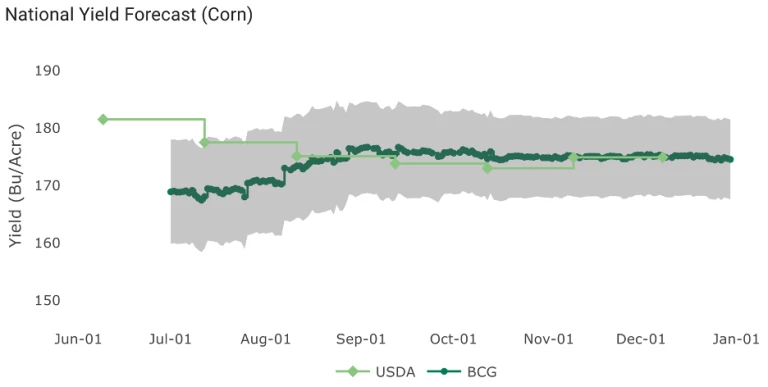
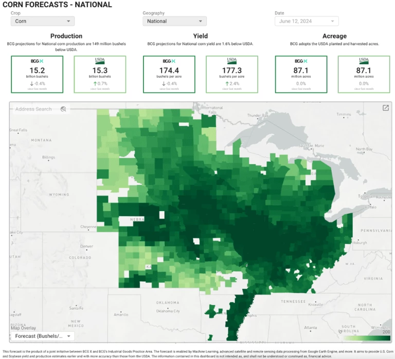
Our model pipeline issued weekly forecasts from July through December. At the start of the season, the BCG forecast was ~10 bushels per Acre lower than the overly bullish June and July USDA forecasts – picking up on the impact of early season drought conditions across much of the corn belt. As the season progressed and timely rain was delivered across the corn belt, our model revised yield estimates upwards, driven by satellite and weather observations. By the end of the growing season in December, our model was in complete alignment with the USDA, forecasting a 174 bushels per Acre national corn yield.
As far back as July, BCG’s forecast was more accurate than the USDA’s forecast.
Pioneering the New Frontier of Business Intelligence
The future belongs to those who embrace innovation as a means of transformation. And amidst the swirling uncertainties of our time, satellite remote detection offers a powerful opportunity for businesses to move beyond passive observation to strategic decision-making. Guided by human-centric frameworks such as BCG X's 10/20/70 approach, organizations can confidently harness satellite remote detection for business intelligence—transforming data into knowledge and uncertainty into opportunity.
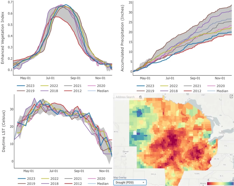
Our forecast model was based on a mixture of satellite and weather data features. Our Enhanced Vegetation Index was a measure of the volume of vegetation on corn-producing cropland, as measured by satellites. Precipitation, temperature, and other weather features also had strong predictive power, especially given that many regions across the corn belt experienced a drought in the early months of the season.
Our development team and experts were instrumental to our success in this endeavor. The team included Pamela Bellavita, Eden Bensaid, Jack Betcher, Christina Chou, Liam Connell, Yukang Liu, Vaishnavi Muthukrishnan, Raleigh Potluri, Anton Van Pamel, Lakshay Vohra, and Adam Wlostowski.


